The Heritage Park Intranet
The Heritage Park Intranet |
||||||
| Artefacts | Archives | Masters | History | Notices | ||
Following the report compiled by the Northamptonshire Archaeology for the National Trust, certain information became available that casts doubts on the current understanding of the building of the 1831 Pitstone Green Farm. The basic premise has so far been, that in 1831 the present farm was built on the site of an earlier farm and the "Big Barn" and a smaller building called the Stevens or Stivens barn were already in existence on the site, and formed part of an earlier farm. A study of the information now available suggests that the site of the present farm was a "green field site" and that no buildings existed on that site, other than the possibility that the Stevens barn still remained and was part of the earlier farm.
Following a talk at one of the monthly meetings of PIMS, an expert in historic buildings identified the Big Barn as dating from c 1650 and would have then been of a simple rectangular construction, somewhat shorter than the existing barn and with no alcoves. Based on the current assumption that the barn was already erected on the present site, then the two alcoves and the rear and front extensions were assumed to be added during the construction of the present farm and the farm house from 1831 onwards. To my knowledge this was how Jeff Hawkin's understood the build of the present farm
It is now suggested that the old farm existed to the west of the present site and adjacent to the stream that used to flow though the orchard of the present farm. The farm of 1831 was built on a 'green field' site to the west of the old farm. The existing 'Big Barn' was dismantled and transferred to the present site, either from the old farm or more likely from another estate and re-assembled on the present site together with other salvaged buildings, some possibly from the old farm. That the alcoves and extensions of the 'Big Barn' were all incorporated at the same time when the side buildings were added to the barn and apart from some later smaller additions the bulk of the farm was constructed in one operation, although over a period of several years
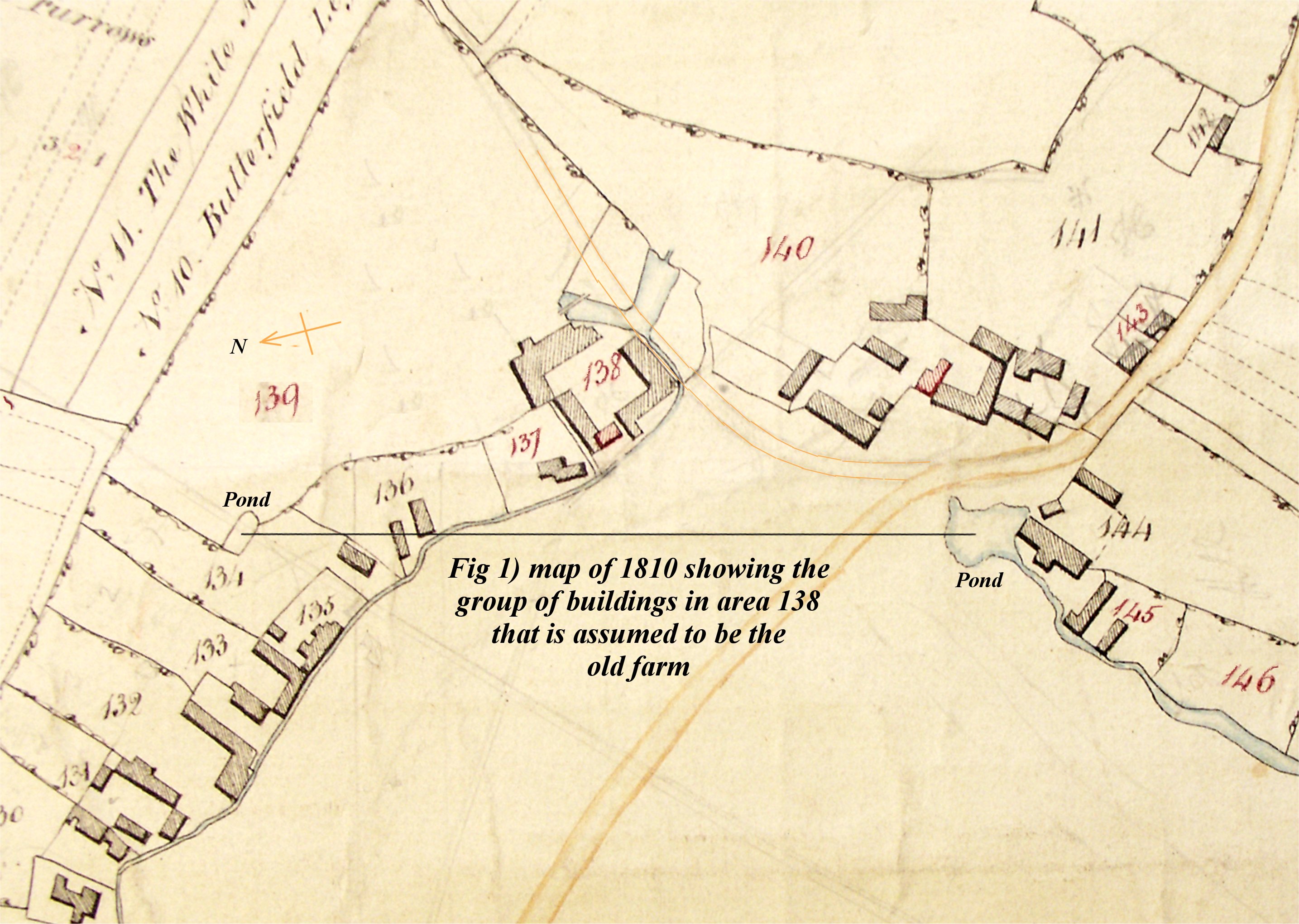
PIMS already holds an original maps dating from the 1840's. Although not in the best of condition it is very detailed and show all the features described in the National Trust's report. All the small holdings are shown along and east of the stream that originally that ran through our orchard with other buildings to the south of the stream as it turned west towards the present Pitstone playing fields. The small holdings were continuous along the stream apart from a gap when the present farm lies. No buildings exist to the east of the steam as that was common land. The only map that the museum had access to appeared in the publication by the Pitstone Local History Society called "At Pitstone Green there is a Farm" and is dated 1810. It was only when the report by Northamptonshire Archaeology for the N.T. appeared that the map of 1810 was compared with that of 1840.
The 1810 and the 1840 maps were almost identical apart from the facts that buildings shown on the 1810 map, near to the present farm and alongside the stream were not shown on the1840 map. Conversely on the 1810 map there was no sign of any buildings on the present museum site.
Based on the assumption that the Big Barn must have existed in 1810 it has always been assumed that the buildings shown only on the 1810 was the old farm and this was also the site of the present farm which may prove to be an incorrect assumption.
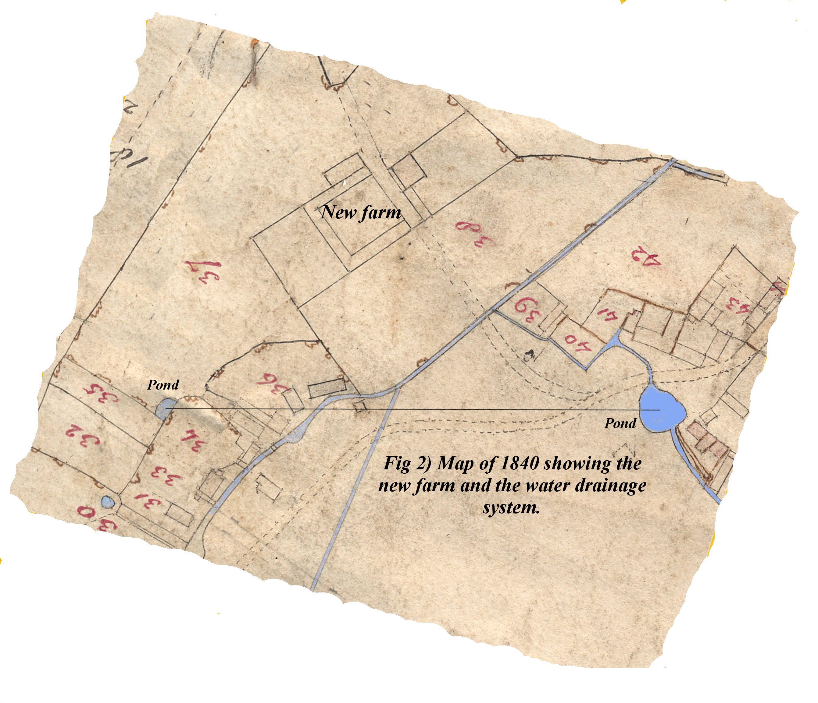
In order to determine the correct interpretation both the 1810 and the 1840 map were scanned on a computer in order to undertake a comparison. It is of course essential to ensure that both maps are of the same orientation and of the same scale to carry out a direct comparison. In order to carry this task two features have been chosen that are on both maps and that can never have been moved during the period from 1810 to 1840. Water features are the most reliable items and two ponds were chosen as reference points. In fact the location of both these water features is traceable on a map even as late as 1925. One of these ponds existed in the field to the north of the present farm and the other in the region of the Pitstone Memorial Hall. Using a computer, a line was drawn on a copy of each map between the centres of the two ponds. Each computer map was then rotated such that the lines were horizontal and one map altered in size until the lines were of equal length, thus the maps had the same orientation and scale. One of the maps was printed on plain paper and the other on a transparency allowing one map to be laid over the other to compare various features. The course of the stream that previously existed in our present orchard together with a large number of the small holdings matched almost perfectly on the two maps.
The following differences however were noted:-
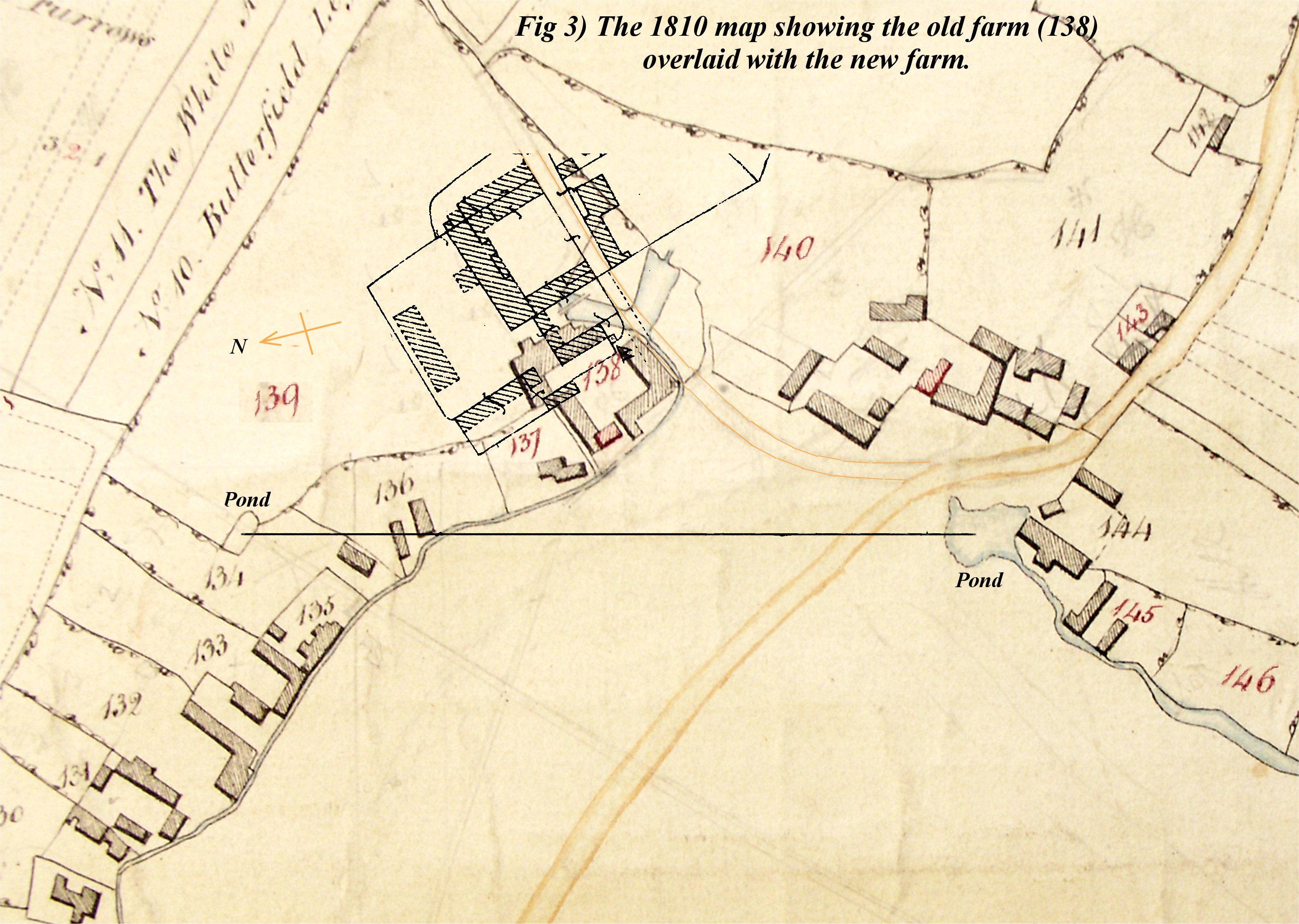
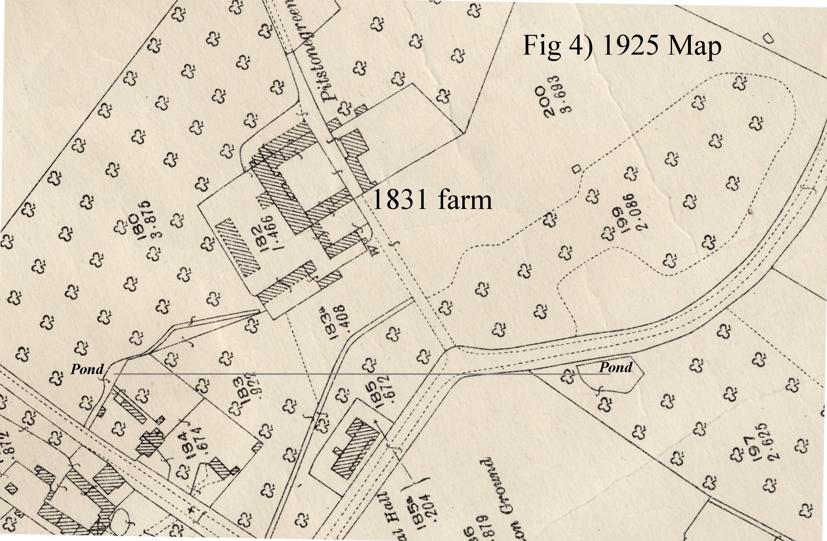
The map of 1840 only shows a basic outline of the present farm and not the extension added in 1913 (the current toilet block, reception and exhibit rooms). In order to compare the current site layout with the old farm shown on the 1810 map an overlay was prepared from a map dating from 1925 again adjusted for scale and orientation. Thus a detailed layout of the old farm and the new farm can be directly compared.
The following points were noted:-
Four maps are attached to this document and they are:-
Fig 1) The map of 1810 showing the two ponds used as a reference for scale and orientation
 click image to enlarge
Fig 2) The map of 1840 showing again the two ponds and the basic layout of the present farm prior to 1913.
 click image to enlarge
Fig 3) An overlay of the two maps with the present farm overlain onto the 1810 map.
 click image to enlarge
Fig 4) A close up of the new farm 1925
 click image to enlarge
The water features around Pitstone Green Farm and revealed by a study of the two maps may give an in-site into the reasons why the old farm was moved from its existing site further east and why the streams were culverted.
From the 1810 map there are four main water features shown:-
Some linkage may have existed between these four water features but could have only been in the way of ditches. No other connection appears on the 1810 map. This suggests that the area would have been prone to flooding, as is Vicarage road even today, when heavy rain occurs. It is suggested that a flood prevention scheme was undertaken between 1810 and 1840 that involve linking three of the four systems together in an underground drainage system. The stream from Moat farm was linked into the pond near the Village hall which in turn linked into a deep culvert in our present orchard. Part of the old stream flowing to the north-east was eventually filled in and the water diverted via the culvert to the Pitstone Cross roads and on further to the north. The 'L' shaped body near the old farm was dispensed with and the new farm re-sited to higher ground to the east of the old farm.
Apart from the information obtained from the two maps other information can be obtained by a study of the buildings themselves.
The most convincing feature that suggests that it was imported to the site and erected at the same time as the alcoves and the extensions, is the low brick wall on which the Big Barn, the alcoves and the extensions stand. If the 'Big Barn' already existed and other features added later one would expect breaks or changes in the brickwork where alterations or additions had been implemented. A visual check however could not detect any variation or discontinuities in the brickwork whatsoever from one end of the building to the other, including the alcoves and the extensions. This alone suggests that there was only one construction phase.
The other observation relates to the types, ages and workmanship of the timbers of which the buildings are constructed. Some timbers are obviously 17th or 18th century, cut in a relatively primitive manner. In other cases roof supports are saw oak with high standard of finishing and jointing yet capped with softwood cross members. The general feel of the construction is that large quantities of timber, section of buildings or indeed whole buildings salvaged from other sites had been used to create the present farm. If one was being unfair it could be called 'cobbled up'
The old farm nestled between small holdings and although somewhat larger than the surrounding holdings one wonders if they would have the means to provide a large timbered barn such as the one on the present site, hence the reason for suggesting that it may have come in as a 'kit of parts' from another estate.
If the build of the present farm did extend over a period of many years then farming of the land must have continued without interruption, suggesting that the old farm was still operational whilst the new farm was under construction although no map appears to exist that show both farms together.
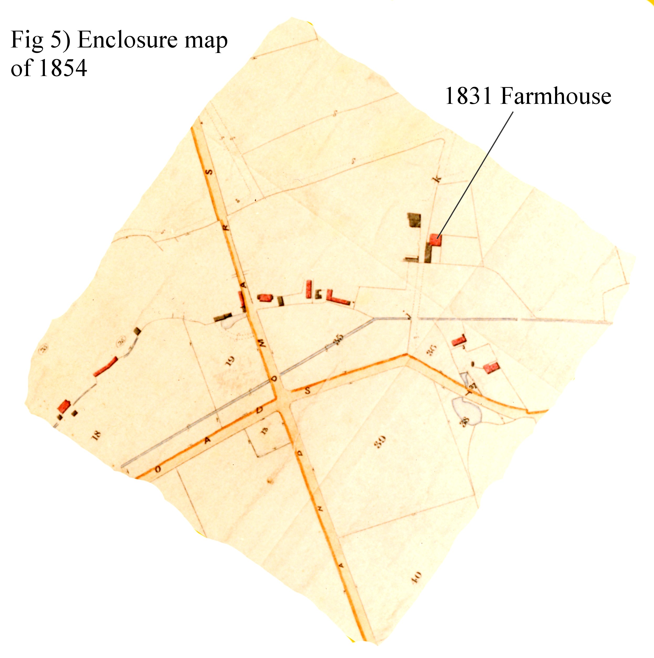
One difficulty remains however, this is explaining why the enclosure map of 1854 (Fig 5) shows the farm house and one or two small buildings but not the Big Barn with all its additional attachments. Could it be that although the build of the new farm has been quoted as 1831, the construction of the whole complex took a considerable number of years to complete and the details on this map shows the true state of build in 1854. However earlier maps of 1843 do show the Big Barn and its associated extensions. If plans did exist in 1840 of the final development may be that they were incorporated on the 1840 map even though the build had yet to be completed? In the 19th century map could not be easily reproduced, each being hand drawn, so older maps may well have been updated in later years.
 click image to enlarge
A study of the maps and the construction of the central buildings of Pitstone Green Farm suggests that it was not built on the site of an earlier farm and that the 17th or 18th century Big Barn was imported from elsewhere when the present farm was built in the early 1830's.
That the Stevens barn and possibly the well in the Owen Barn could be the sole remaining structures of the old farm.
PIMS has no one with experience in historic building construction or indeed knowledge of the Enclosure Act that was implemented in the early 19th century and professional help would enable us to prove or disprove the above theory. There remains a wealth of detail on the site yet to be studied, for example the floor construction of the Stevens barn or the recently discovered well which may be dateable. The ownership of the surrounding strips that predated the enclosure and why some strips numbers are in red why others are in black ink. A survey using ground radar or ground resistance measurements in the orchard may uncover the secrets of the old stream and its small holdings lining the eastern bank. Perhaps the N.T. may have the facilities available that are not available to PIMS.
Norman Groom, Pitstone Green Museum.
| Quick Links: | |||||
| About | Artefacts | History | Master Documents | Terms and Conditions | |
| Accreditaion | Constitution | Interactive Map | Movement Forms | ||
| Archives | Fire Extinguishers | Location Codes | Noticeboard | ||
| © 2025 Pitstone & Ivinghoe Museum Society Pitstone Green Museum, Vicarage Road, Pitstone, Leighton Buzzard. LU7 9EY Registered Charity No. 273931 |